
Pixxel: The Indian Space Startup Making Earth’s Hidden Problems Visible from Orbit
TECHNOLOGY
4/27/20256 min read
🔭 Pixxel: The Indian Space Startup Making Earth’s Hidden Problems Visible from Orbit
By Arjun • 6 min read • SpaceTech | Climate Intelligence | Future of Earth Observation
📌 Quick Summary:
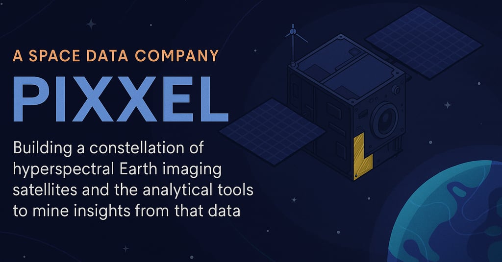
Pixxel is building the world’s highest-resolution commercial hyperspectral satellites.
Their technology reveals hidden data like crop disease, pollution, and mineral composition.
Backed by Google and NASA, Pixxel aims to deploy 24 satellites for daily global coverage by 2026.
What if we could see the Earth from the top in detail than ever before - not just colors, but chemicals, crops, and climate changes unfolding in real time?
That is the mission behind this company Pixxel, a space-tech startup from Bengaluru, India with global ambitions. It has set up another office in El Segundo, California, USA. At first glance, they might seem like any other satellite company. But going a little deeper into their website, you will find something interesting and extraordinary: Pixxel is building a constellation of hyperspectral imaging satellites - and using them to unlock secrets hidden in plain sight on Earth.
What does this mean in layman terms?
Pixxel is launching a group of satellites that are special in the way that they see more than regular cameras - they can detect things like pollution, crop health, and water quality - even if we cannot see them with out eyes. Basically these satellites help to spot problems on Earth early, so people can fix them before they get worse.
Here is a scenario that has been put to test:
Imagine you are a farmer with huge field of crops. To your eyes, everything looks green and healthy. But underground, some plants are not getting enough nutrients - and a disease is starting to spread,. You cannot see it yet, but it is there.
Now consider a satellite flying hundreds of kilometers above the Earth, taking a super-detailed image of your field - not just in color, but in hundreds of invisible light layers. This image shows where the crops are starting to get sick, even before the leaves of the plant turn yellow. It deciphers exactly which part of the field needs attention.
This is what Pixxel satellites do: they spot the problem in advance - like crop disease, pollution, or gas leaks - by using powerful sensors that see what normal cameras cannot. They give us a first initial advice to fix things before they become big and expensive problems.
Pixxel's real superpower lies in capturing hyperspectral images - data - rich snapshots of the Earth taken across hundreds of light wavelengths. This allows them to detect things that are invisible to the human eye, like:
Nutrient levels in crops 🌾
Early signs of plant disease 🦠
Pollution in rivers and oceans 🌊
Methane leaks and air quality issues 💨
🚀How Did Pixxel Get Started?
The idea started in 2019 when the co-founders, Awais Ahmed and Kshitij Khandelwal (instrumental in leading India's first Hyperloop pod team, Hyperloop India), realized a gap in observation data on Earth. Traditional satellite imagery could only go so far - what if you could see beyond surface visuals and into the actual composition of earth's surface? (as shown above) This exact question led to the company's journey : from university project to startup to a company now partnering with global organizations like NASA and ISRO.
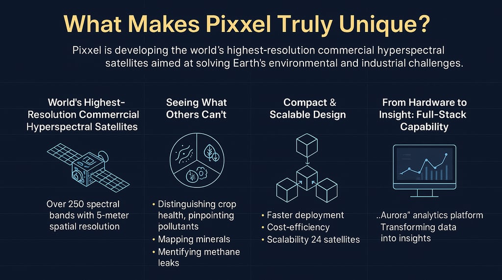
🌟 What Makes Pixxel Truly Unique?
🛰 World's Highest-Resolution Commercial Hyperspectral Satellites
Pixxel’s "Firefly" satellite series boasts the highest spectral resolution in the commercial sector. While traditional multispectral satellites (like those used by most Earth-observation firms) capture only around 4–13 spectral bands, Pixxel’s satellites can collect over 250 distinct spectral bands, spanning the visible and infrared spectrum.
Here it is not only about quantity — it’s about clarity.
Each image taken by a Pixxel satellite comes with a spatial resolution of 5 meters, meaning the data is not just broad-spectrum, but also finely detailed. This allows users to identify minute changes in vegetation health, chemical presence, and composition of material that others companies simply cannot detect.
🔬 Seeing What Others Cannot
With this level of spectral depth and clarity, Pixxel enables use cases that were previously only possible in lab-grade remote sensing. For example:
Distinguishing between healthy and nutrient-deficient crops, even before physical symptoms appear.
Pinpointing specific pollutants or toxins in rivers, oceans, or urban water bodies.
Mapping rare mineral compositions across terrain to guide sustainable mining.
Identifying methane leaks from pipelines long before they become visible or hazardous.
This “X-ray vision” from space unlocks possibilities that go far beyond photography — it enables early warnings, better decisions, and more targeted action.
🔁 Compact & Scalable Design
Unlike bulky hyperspectral satellites of the past, Pixxel’s tech is designed to be compact and modular — fitting into standard small satellite platforms. This enables:
Faster deployment
Cost-efficiency in manufacturing
Scalability to build large constellations
Their roadmap includes deploying a constellation of 24 satellites by 2026, which would offer daily coverage of every point on Earth, a feat that no other hyperspectral imaging provider currently offers.
🧠 From Hardware to Insight: Full-Stack Capability
Pixxel doesn’t stop at data collection. They’ve developed an in-house platform called Aurora, which offers analytics, visualizations, and alerts — transforming raw hyperspectral data into actionable insights for non-expert users.
This full-stack approach — from satellite to insights — means Pixxel isn’t just a data vendor; it’s building an intelligence layer for the planet.
💰 Pixxel’s Financial Status
As of early 2024-25:
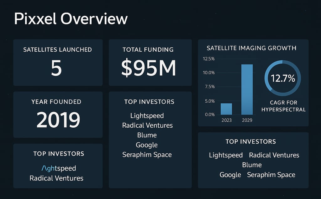
Pixxel has raised around $71 Million+ in funding across multiple rounds.
Major investors include: Lightspeed Ventures, Radical Ventures, Seraphim Space, Blume Ventures, and Google (a Strategic partnership).
Series B round in 2023 resulted in raising ~$36 million, fueling constellation expansion and analytics product development.
The company is also participating in commercial defense and climate monitoring contracts, expanding their revenue model beyond just raw data.
🌍 Current Applications of Pixxel's Technology
Precision Agriculture: Farmers use Pixxel’s data to monitor crop health, detect nutrient deficiencies, forecast pest outbreaks, and improve yield with less waste.
Energy & Infrastructure Monitoring: Companies can detect for example methane leaks, track oil spills, and monitor pipelines or industrial sites for anomalies invisible to the naked eye.
Environmental & Climate Monitoring: Government agencies and researchers use the data to monitor water quality, forest degradation, pollution, and climate stress indicators across the globe.
Mining & Natural Resource Management: Pixxel’s satellites help in locating mineral-rich zones and assessing land usage impact without invasive techniques.
Disaster Management: After floods, droughts, or wildfires, Pixxel’s data can help assess damage faster and guide relief planning.
💸 Market Potential and Financial Trajectory
Pixxel isn’t just launching satellites — it’s positioning itself at the heart of a rapidly expanding global opportunity.
The global satellite imaging market is projected to reach $19 billion by 2029, driven by sectors like agriculture, defense, climate science, and urban development. Within this broader ecosystem, hyperspectral imaging — capable of capturing hundreds of spectral bands — is emerging as a game-changer. This segment alone is expected to grow at a 12.7% CAGR, outpacing traditional multispectral technologies and signaling strong demand for richer, more actionable data.
Pixxel, founded by graduates from BITS Pilani, has so far raised $95 million in funding, backed by renowned investors such as Lightspeed, Radical Ventures, Blume, Seraphim Space, and even Google. Their lean, vertically integrated model — covering satellite design, manufacturing, and data delivery — keeps them capital-efficient while still allowing them to scale operations sustainably.
This financial foundation suggests that Pixxel isn’t just a startup with vision — it's a strategically funded deep-tech player built to last.
🧠 Expert Opinions and External Validation
What sets a promising company apart from hype is third-party validation. In Pixxel’s case, the voices endorsing its mission are both credible and passionate.
Awais Ahmed, CEO of Pixxel, shares:
“We’re building the health monitor of the planet — one pixel at a time.”Investor at Lightspeed Ventures reflects:
“Pixxel is what happens when vision meets execution. They’re not just building satellites; they’re solving planetary-scale problems.”NASA, a strategic partner, affirms:
“Pixxel’s data helps close a critical gap in environmental monitoring.”
These testimonials don’t just reflect confidence — they signal alignment across industry, investors, and institutions on Pixxel’s vision and technical execution.
⚖️ Challenges and Competitive Landscape
Of course, no pioneering mission comes without friction.
Pixxel operates in a competitive and complex global environment. Rivals like Planet Labs (USA), Chang Guang (China), and GHGSat (Canada) are also racing to dominate space-based Earth monitoring. Additionally, regulatory scrutiny on satellite data — especially for defense and remote sensing — is tightening across markets.
Then there’s the data interpretation gap. Hyperspectral imaging generates incredibly detailed datasets, but most end-users today lack the tools or expertise to derive insights.
Pixxel tackles these challenges with bold yet practical solutions:
Aurora, its no-code Earth Observation Studio, makes hyperspectral data analysis accessible to non-experts
Its cost-effective satellite manufacturing and launch approach helps lower the barrier for adoption
And its superior spectral resolution gives it a technical edge over incumbents
🔮 Looking Ahead: Why Pixxel Matters
As the world faces rising climate risks, growing insecurity with food, and deteriorating pollution, tools that help us act early and wisely are no longer optional — they are essential. Pixxel isn’t just watching Earth from space — it’s empowering us to protect it. With their groundbreaking hyperspectral technology, they are making the invisible visible and helping us take timely action.
Whether it’s a farmer trying to save crops, a government preparing for a disaster, or a company monitoring emissions, Pixxel's satellites could be the difference between being reactive and being ready.
🌐 Pixxel's vision is bold — to scan the entire Earth every day, spot trouble before it strikes, and give humanity the foresight to act. Will governments, corporations, and communities be ready to use this insight to change our future?

Explore
Join us on our journey to monetize content.
© 2025. All rights reserved.